Scorched forest farm – Wildbore cache no.7

No. 1 Line
The Neilson Farm on No. 1 Line, Awahou in 1896. Photographed by Charles E. Wildbore. Palmerston North Library.

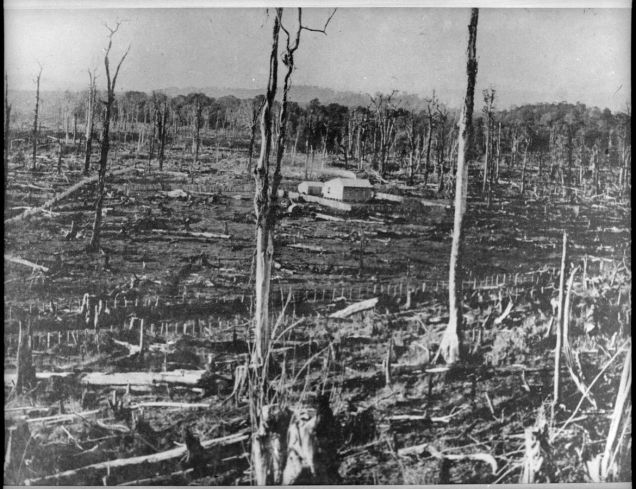
Number 7 in the Wildbore geocache series is on No. 1 Line on the eastern side of the Pohangina Valley.  It was on No. 1 Line that Charles E. Wildbore took one of his earliest surviving landscape photographs, in 1896. The photograph starkly captures the brutal transformation of the landscape by fire. A farmhouse is surrounded by the incinerated limbs and trunks of the forest trees, that until only a few years previously covered the hills and river terraces of the entire valley. While we cannot see this from the photograph, this would likely have been a landscape of oppressive silence – any birds that were able to escape the conflagration would likely have taken refuge in the nearby Ruahine foothills, while introduced birds, such as the sparrow, thrush and blackbird were yet to colonise the valley in substantial numbers. Continue reading

Burning New Zealand’s forests

Of all the photographs I have seen relating to New Zealand’s environmental history, this is one of the most powerful. It shows the beginnings of a bush burn off at Puketora Station on the East Coast of the North Island in the early 1900s. This fire destroyed the indigenous forest over 30,000 acres, to make way for farming (probably of sheep). Continue reading

Volcanoes and farming

How do volcanoes relate to farming?

The early settler-farmers of New Zealand soon recognized the limitations of the fertility of the land which they farmed, particularly when it came to arable crops such as wheat. In regions such as the Manawatu, the “black soils” of burnt-off bush country at first produced prolific crops, owing to the minerals contained within the ashes of the burnt bush. However, quite rapidly, this fertility declined. Continue reading