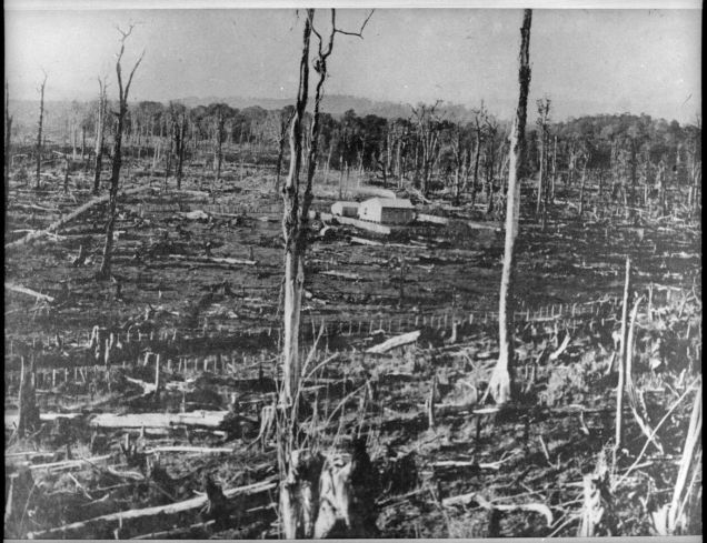
Number 7 in the Wildbore geocache series is on No. 1 Line on the eastern side of the Pohangina Valley. It was on No. 1 Line that Charles E. Wildbore took one of his earliest surviving landscape photographs, in 1896. The photograph starkly captures the brutal transformation of the landscape by fire. A farmhouse is surrounded by the incinerated limbs and trunks of the forest trees, that until only a few years previously covered the hills and river terraces of the entire valley. While we cannot see this from the photograph, this would likely have been a landscape of oppressive silence – any birds that were able to escape the conflagration would likely have taken refuge in the nearby Ruahine foothills, while introduced birds, such as the sparrow, thrush and blackbird were yet to colonise the valley in substantial numbers.
This was the farm of Charles Neilson and his wife Sarah Alma Neilson, whose children Eileen, Charles and Alma (and perhaps others too) attended nearby Awahou (North) School (see Can you help solve the mystery behind this photo?). In a stroke of irony, the Neilsons were to later suffer themselves from the brutal and merciless effects of fire. In 1908, the Neilson’s property was one of a number damaged by a bushfire (most likely a bush burn that got out of control). The Manawatu Standard reported:
“The bush fires are still alive, and as the wind rises the fires start again. The land on the east side of the river is damaged more or less. The fire has been over thousands of acres; fences are flat in all directions, and settlers still apprehend danger unless we get an immediate downpour of rain, and until then the damage cannot be estimated. The old pioneers have endured many hardships. They have made comfortable homes, and the thought of a fire sweeping them out of existence is heartrending” (Manawatu Standard, 25 January 1908).
 As an aside, Pohangina East is distinguished by its “lines” – Lines No. 1 through to No. 4 (see The school that moved: Wildbore geocache no. 1) – which were surveyed using these highly practical appellations but never bestowed “proper” names, as roads were in other parts of the country. In fact this was a phenomenon that characterised the Manawatu generally – see When is a road a line? The curious case of Kairanga County which explains the history.
See Wildbore: A photographic legacy (Totara Press, 2018) for more photographs of this area, and Ravaged Beauty: An environmental history of the Manawatu (Dunmore Press, 2014) for a more general history of the Manawatu.
For more information about geocaching see The school that moved: Wildbore geocache no. 1


Brutal is the right word……. Geocaches; what a great idea!