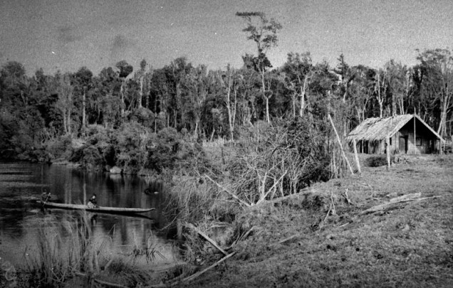
 A few months ago, I posted the story, The city of hidden lagoons: Palmerston (of the north), which explored the watery history of the Manawatu city of Palmerston North, where I grew up. In particular, the post told a little of the story of the long-forgotten Awapuni Lagoon, which once lay in the south-west corner of the city. This post will add to that story, with the history of the Mangaone Stream, which fed into the Manawatu River in the same area of the lagoon. Both the Lagoon and the stream were an important source of eels and a bird harvest area for the Rangitane. The stream was also an access route to settlements further inland from the Manawatu River.
  Perhaps it was for these reasons that Rangitane chose to establish a small village there, on the northern side of the lagoon (adjacent to the present Pioneer Highway). The village was known as Awapuni, and was established about 1866. A meeting house named “Kikiwhenua” was built at this village in 1883, when Tawhiao (the Maori King) first visited Manawatu. This house was in use until 1925, when it was destroyed by fire.
 Subsequent to European settlement of the area, the stream was modified significantly to manage drainage and prevent flooding, leading ultimately to the destruction of the lagoon. A major stream diversion in 1907 redirected the Mangaone into the Awapuni Lagoon and drained the lagoon directly into the river, thereby destroying an important fishery and recreational asset.
In her book, published in 1954, recounting life in Palmerston North in the 1880s and 1890s, Charlotte Warburton describes the lagoon, and its gradual (but irrevocable) degradation:
“Awapuni Lake, fringed with bush, all the lovely foliage of ferns and trees, down to the water’s edge, was a fine place for canoeing, it was so sheltered and calm. Many native and imported birds were to be seen… The native grey duck were plentiful there also, they could have been seen, sometimes making rapid flight across the water, making a curious whistling sound which is characteristic of them.
This lake has unfortunately become silted up from a deep cut that was made into it, so it is much smaller and the bush trees having long ago become very depleted, it has lost its beauty and is not so interesting.”
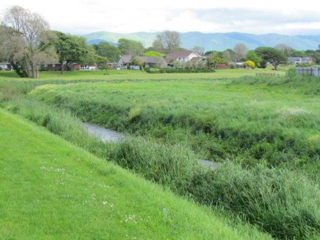
Even today, a distinct depression in the ground marks the site, which functions as a ponding area for the city’s stormwater during times of high rain-fall.
See also: The city of hidden lagoons: Palmerston (of the north)
Photo top left: A group canoeing at Awapuni Lagoon in 1890 (Photo: G. W. Shailer). Palmerston North City Library, digitisation ID no.: 2007N_Awa2_A-E_0297. Middle: The Awapuni Lagoon 1881. Written in pencil on the old print are the words: “Awapuni Lagoon 1881. Returning to Pah from Waldegraves”. Note the old wharepuni (principal house of a village) on the right, part of the Awapuni Maori settlement between the Foxton to Palmerston North Road and the northern bank of the Lagoon. The people in the canoe are probably the Mr and Mrs W H Luxford and daughter. Palmerston North City Library, digitisation ID no.: 2007N_Awa1_EPN_0252. Above: Mangaone Stream today, taken from the site of the interpretative sign at Pioneer Highway, showing a depression where the lagoon once was (Photo: C. Knight).
Sources: Interpretive signs at the entrance to the Mangaone Stream walk at Pioneer Highway (where the photo was taken). Notes on the Maori History of Palmerston North (1986), by Ian Matheson, Palmerston North City Archivist. Digitisation ID no.: 2007Pa_A75-8-4_HIS_0539.

Thank you to the Palmerston North City Council staff member who alerted me to the interpretative sign recently erected at the former site of the lagoon. Nothing will undo the history that destroyed this lagoon and degraded the stream that flowed by it, nor the undermining of the relationship between the Rangitane people and these waterways. However, the marking of this site and the acknowledgement of this history, in a way that is accessible to all, is a first step towards understanding our environmental past, and hopefully, learning from it.
Your hydrological history is much appreciated.